Making Smarter Decisions Under Scarcity: Decision Intelligence and Water Management in the Yakima River Basin
The Yakima River basin is a snapshot of the water crisis facing the American West. It supports a $4.5 billion agricultural economy, nearly 400,000 residents, and some of the most important salmon and trout habitat remaining in the Pacific Northwest.1 If you’ve eaten a really good apple, had a great microbrew with hops-forward flavor, or eaten red cherries in the recent past, chances are these products were grown in the Yakima River valley. All of this depends on a river system that is structurally over-committed and increasingly stressed by drought and a changing climate.
That climate stress matters because the basin is shifting away from a snowpack-dominated water cycle toward one driven more by winter rain and reduced summer runoff. Operational approaches built around historical snowmelt patterns will increasingly fail as those patterns change. Three consecutive drought years have tested every assumption built into the basin’s governance framework. A fourth drought year in 2026 has just been declared.2
Against this backdrop, decision intelligence (DI) has a specific and urgent role to play. Decision intelligence means designing the process by which people in charge actually make choices. Instead of just giving them better data, DI provides a structured, repeatable way to use that data to improve the quality, speed, and consistency of decisions in complex systems.
The central challenge in the Yakima basin is not a lack of information. It is the absence of structured decision workflows that can bring existing information together, honor the legal hierarchy of water rights, and connect short-term operational choices to long-term outcomes.
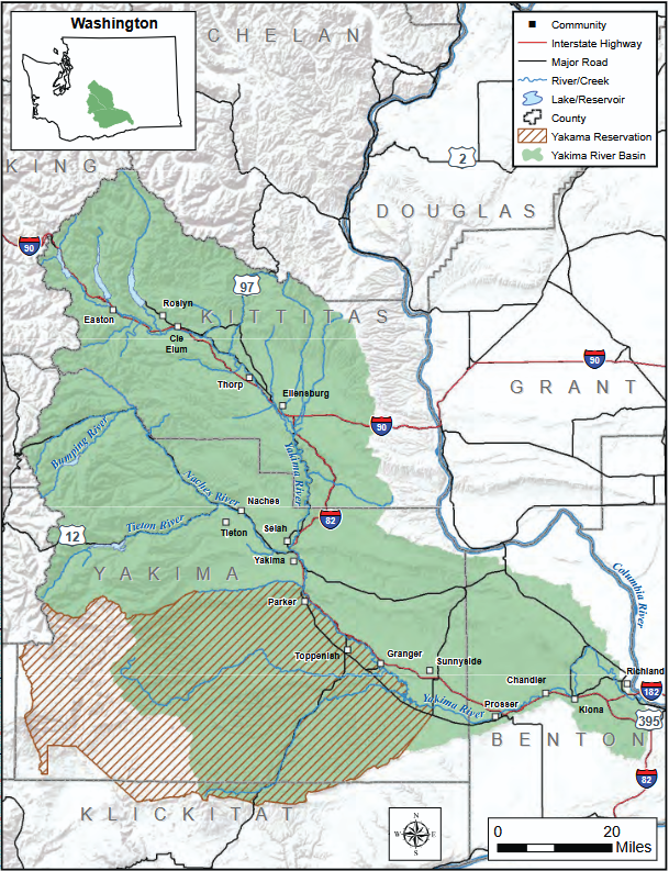
Figure 1. The Yakima River Basin, from [1].
Two Goals That Define Success Each Year
While there are multiple outcomes around which a DI workflow could be built, there are two operational targets that define success in any given year.
The first is maintaining a water supply equivalent to at least 70% of what junior water rights holders are entitled to receive. This threshold is written into the Yakima River Basin Water Enhancement Project and represents approximately 896,000 acre-feet of water, roughly enough to supply 800,000 households for a year.1,3 Junior water rights holders account for more than half of all water rights in the basin and bear the full burden of shortage years. When deliveries fall significantly below 70%, the economic damage to orchards, row crops, and rural communities compounds quickly and can be difficult to recover from. During the 2025 drought, junior rights holders received only 43% of their entitlements.4
The second target is maintaining enough water flowing through the river system to support salmon and trout throughout their habitat. The Yakima River is home to steelhead and bull trout listed as threatened under the Federal Endangered Species Act, as well as spring and fall Chinook salmon whose populations are closely watched. The basin was once one of the Columbia River’s most productive areas for these fish. The U.S. Bureau of Reclamation has developed target flow levels intended to guide reservoir operations toward seasonal water patterns that better support fish survival and movement.5 These required flows are dynamic, depending on life stages, fish location, and climatic variation.
These two outcomes are deeply connected and sometimes compete in ways that force hard choices. Releasing water in May to keep fish passage open may mean there’s less in storage when farmers need it most in August, when river temperatures are highest. Decision intelligence provides a framework for managing that tension deliberately rather than reactively.
What Decision Intelligence Brings to the Table
DI is a systematic approach to structuring choices. It means identifying the key decision points, specifying objectives and constraints, connecting quantitative models to business rules and processes, and making the reasoning behind decisions transparent enough that it can be evaluated, challenged, and improved over time. In the Yakima context, it means building a decision workflow that moves from water supply forecasting through legal prioritization to operational release scheduling, with clear accountability for outcomes at each step.
We will build a DI design through the construction of a causal decision diagram (CDD), which shows factors that cause different outcomes, variables that can be controlled, and where models or data feed into the decision process. A CDD organizes the key elements of a decision into columns: externals (factors outside anyone’s control), levers (actions decision-makers can take), intermediates (effects that occur between changing a lever and realizing an outcome), outcomes (what we want to achieve) and goals (the exact targets we’re trying to hit). Figure 2 shows the CDD for the Yakima basin workflow. To read it, trace any causal path from left to right: for example, snow water equivalent (an external) feeds into remaining catchment volume (an intermediate), which affects the volume released from catchments (a lever) through a feedback loop, which in turn influences stream flow in fish habitat (an outcome tied to the fish goal). If you’ve read previous posts in this series, this may be the first time you’ve seen a feedback loop in a CDD (but it won’t be the last!).
The Non-Negotiable External: Yakama Nation Treaty Rights
Any decision workflow in the Yakima basin must begin with one inviolable constraint: the water rights of the Yakama Nation, established through the Treaty of 1855.3 That treaty retained for the Yakama people inherent fishing, hunting, and gathering rights, including the right to fish at all their usual and traditional places. These rights predate every other water right in the basin and stand above the priority system that governs all other irrigation and municipal rights.
Even during the unprecedented 2025 curtailment order, in which Washington State’s Department of Ecology restricted surface water use across the entire basin for all but the most senior holders, the Yakama Nation’s 1855 rights were explicitly outside the scope of that order. This is not a modeling parameter; it is a constitutional reality.
In practical terms, any reservoir release schedule must first satisfy the Yakama Nation’s water and flow obligations before allocating water to other rights holders. The value of decision intelligence here is not in finding ways to work around treaty rights. It is in making those rights computationally explicit, traceable in model outputs, and reportable in a way that supports genuine co-management with the Yakama Nation as a full partner in basin governance.
Groundwater: The Hidden Variable That Affects the River
Decisions about how much water to release from reservoirs cannot be made in isolation from what is happening underground. USGS groundwater studies documented approximately 312,000 acre-feet of groundwater pumped in the Yakima basin in a single year, with roughly 60% used for irrigation.6 Modeling found that pending permit applications at the time could reduce river flows by an additional 91 cubic feet per second, a significant reduction during the summer low-flow period when river levels are already at their most critical for fish.
The reason groundwater pumping affects the river is that the underground water system and the river are connected. When users pump from wells, they gradually pull water toward those wells from the surrounding ground, which over time reduces the amount of groundwater seeping into the river and its tributaries.7 A well-designed decision workflow treats groundwater pumping as an active variable in the water balance calculation, not a fixed background assumption.
Models Power the Workflow
The Yakima basin already has substantial technical modeling infrastructure. The U.S. Geological Survey and the Bureau of Reclamation have applied a modeling platform called RiverWare to the basin since the late 1990s. RiverWare is a computer simulation tool that models how water moves through a system of reservoirs, canals, and river channels, and how water rights rules affect who gets water and when.8 Peer-reviewed research published in 2019 found that combining RiverWare’s reservoir outputs with a complementary tool called SWAT substantially improved the accuracy of water flow predictions in the basin, confirming that the existing modeling framework can serve as a credible foundation for decision support.9
A DI approach treats these models not simply as analysis tools but as scenario engines embedded in a recurring decision process. At the start of each season, snowpack measurements, reservoir storage levels, and precipitation forecasts feed into a set of possible futures for the year’s water supply. These scenarios run through the reservoir operations model to estimate how much water will be available across the summer, the core input to the prorationing calculation the Bureau uses to set delivery percentages. (Prorationing is the legal process of proportionally reducing all junior rights holders’ allocations during a shortage.) The Bureau currently publishes updated analyses every two weeks when proratable supplies are near or below 75%.
A decision intelligence framework formalizes this into a disciplined decision cycle: observe, forecast, evaluate against both objectives, decide, and monitor for whether outcomes are tracking as expected. Careful attention must also be placed on how often release volumes are adjusted: complex systems are notoriously sensitive to the timing of feedback loops.
Short-Term Decisions and Their Long-Term Consequences
Every in-season decision about how much water to hold in or release from the basin’s five major reservoirs creates a path dependency that constrains the options available later in the summer. The Yakima Basin Integrated Water Resource Management Plan is a 30-year, $3.8 billion framework authorized by Congress in 2019.3 It includes new water storage, fish passage facilities at all Bureau dams, habitat restoration, water conservation investment, and water markets that allow flexible transfers during shortages. But major infrastructure pieces will take years to complete. In the meantime, in-season operational decisions are the primary tool available to managers.
Decision intelligence makes the connection between short-term decisions and long-term plan outcomes visible and actionable. If a release decision in May draws down Cle Elum Reservoir below the storage level needed to support fish passage operations at a newly constructed fish ladder, that short-term decision undermines a long-term capital investment made specifically to serve the plan’s ecological goals. A decision workflow that tracks reservoir storage against plan-consistent operating targets, updated as forecasts change throughout the season, can flag these conflicts before they become irreversible. That creates the opportunity for proactive responses such as temporary water market leases, voluntary demand reductions, or accelerated conservation programs.
The decision intelligence framework must also build in scenario planning across a range of possible climate futures, not just optimizing for the most likely year but also testing how decisions hold up under the worst projected drought conditions.
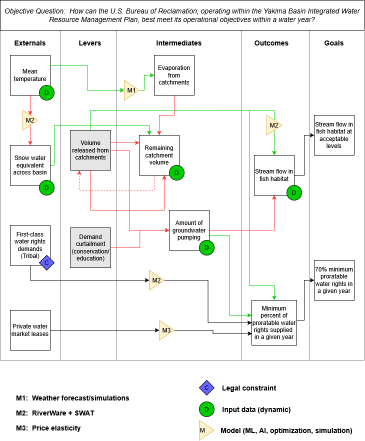
Figure 2. A Causal Decision Diagram (CDD) for the DI workflow discussed. Green arrows indicate positive relationships, red arrows indicate inverse relationships. Credit: author.
Building the Decision Workflow
An initial decision intelligence framework for the Yakima basin integrates five layers. Each builds on the one before it, turning raw data into legally grounded, ecologically aware, and strategically coherent decisions.
Water Supply Forecast
Pulls together real-time snowpack data, reservoir storage readings, and precipitation forecasts to produce a range of scenarios for the year’s water availability.
Legal Constraints
Encodes the water rights priority hierarchy — starting with Yakama Nation treaty rights, then senior surface water rights, then junior proratable entitlements — as firm boundaries that any allocation must respect.
Operations Model
Uses RiverWare or a combined RiverWare-SWAT configuration to translate allocation scenarios into flow predictions at specific points along the river, enabling evaluation against both the 70% delivery target and fish flow requirements.
Groundwater & Demand
Incorporates pumping estimates and projected water use as active variables that affect river flows, rather than treating them as fixed background conditions.
Long-Term Consequences
Maps each candidate decision against the Integrated Plan’s multi-year storage and flow targets, flagging choices that may look reasonable in the short term but quietly undermine the plan’s longer-term goals.
None of these components needs to be built from scratch. The models exist. The legal framework is established. The monitoring infrastructure is in place. The decision workflow architecture connects them into a coherent, accountable, and adaptive system that learns over time. That system needs to be one that the Bureau of Reclamation, the Washington Department of Ecology, the Yakama Nation, and the irrigation districts can jointly own and genuinely trust.
Conclusion
The Yakima basin has spent decades building the legal and institutional foundations for collaborative water management. Decision intelligence is the methodology that can help turn that collaboration from a process of managed conflict into a genuine decision-making advantage — one capable of sustaining both agricultural livelihoods and thriving salmon and trout populations through the droughts and decades ahead.
References
Yakima integrated plan - Washington State Department of Ecology. https://ecology.wa.gov/ecologys-work-near-you/river-basins-groundwater/yakima-river-basin-projects/yakima-integrated-plan.
Statewide drought declared due to dismal snowpack. https://ecology.wa.gov/about-us/who-we-are/news/2026/april-8-statewide-drought-declared-due-to-dismal-snowpack.
The Integrated Plan. Yakima Basin Integrated Plan. http://yakimabasinintegratedplan.org/the-integrated-plan/.
Herald-Republic, T. A. Y. Yakima Basin water forecast drops to 43% for junior rights holders. Yakima Herald-Republic (2025).
The System Operations Advisory Committee. Report on Biologically Based Flows for the Yakima River Basin. (1999).
USGS - Yakima River Basin Project - Summary of Results. https://wa.water.usgs.gov/projects/yakimagw/summary_of_results.htm.
Ely, D. M., Bachmann, M. P. & Vaccaro, J. J. Numerical Simulation of Groundwater Flow for the Yakima River Basin Aquifer System, Washington. U.S. Geological Survey (2011).
Zagona, E. A., et al. Riverware: A Generalized Tool for Complex Reservoir System Modeling. JAWRA 37, 913–929 (2001).
Qiu, J. et al. Implications of water management representations for watershed hydrologic modeling in the Yakima River basin. Hydrol. Earth Syst. Sci. 23, 35–49 (2019).